


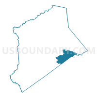
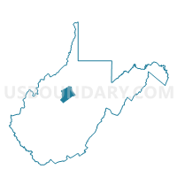
Voting District 18, Gilmer County, West Virginia
About
Outline

Summary
| Unique Area Identifier | 690611 |
| Name | Voting District 18 |
| County | Gilmer County |
| State | West Virginia |
| Area (square miles) | 12.84 |
| Land Area (square miles) | 12.77 |
| Water Area (square miles) | 0.07 |
| % of Land Area | 99.43 |
| % of Water Area | 0.57 |
| Latitude of the Internal Point | 38.87252940 |
| Longtitude of the Internal Point | -80.73455640 |
Maps

Graphs
Select a template below for downloading or customizing gragh for Voting District 18, Gilmer County, West Virginia


Neighbors
Neighoring Voting District (by Name) Neighboring Voting District on the Map
- Voting District 17, Gilmer County, WV
- Voting District 20, Gilmer County, WV
- Voting District 28, Braxton County, WV
- Voting District 37, Braxton County, WV
- Voting District 45, Braxton County, WV
- Voting District 5, Gilmer County, WV
Top 10 Neighboring County Subdivision (by Population) Neighboring County Subdivision on the Map
- Northern district, Braxton County, WV (3,730)
- City district, Gilmer County, WV (3,467)
- Glenville district, Gilmer County, WV (1,832)
- Center district, Gilmer County, WV (1,690)